
Project: Wave Study
Client: Sasaki Associates Inc, Watertown MA
Location: Charleston South Carolina
Key Design Problems Addressed:
- Design water levels and waves
- Current measurements
- Evaluation of alternative marina layouts
- Bathymetric data collection
Daniel Island Marina is a proposed 320-slip marina designed to accommodate yachts from 30 to 120 feet in length along a natural bend in the Wando River, 10 miles from the Port of Charleston. The marina is designed to withstand Category 2 hurricanes and surge levels while maintaining excellent flushing during normal conditions with minimal use of breakwaters.
CSE was retained by the master planner, Sasaki Associates Inc (Boston, Massachusetts, USA) and the owner, Daniel Island Company, to assist the design team with coastal engineering analyses of waves, tides, and hurricane loads on the marina docks. CSE’s work included detailed time-series measurements of waves, currents, water levels, and bathymetry with all field data collection via CSE personnel and equipment. The field data were combined with historical bathymetry to develop a model grid for analysis of normal and design flows, waves, and water levels. The US Army Corps of Engineers’ (USACE) Surface Water Modeling System (SMS) was used to develop a numerical model of flows and water levels within the applicable portion of Wando River, a broad coastal plain tidal river.
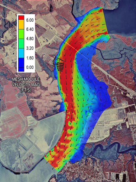
RMA2, a two-dimensional depth-averaged finite model, was used to compute water-surface elevations and horizontal velocities under normal and design conditions. [Graphics on following page show modeled flow at maximum surges.] CSE’s field measurements were used to calibrate the model. A Sontek ADCP was used in the dynamic mode to measure discharge over a complete tidal cycle along one transect at the marina site across the Wando River. The model results provided an envelope of current peak, ebb, and flood velocities across the channel. The measured and modeled current velocities and water levels showed good correlation (r>0.94). Category 2 and 3 hurricane winds and fetches were evaluated to establish design water levels and wave setup at the site. The 25-year return-period water level was determined to best represent Category 2 hurricane storm conditions. Design wave height and period for the relevant fetches and specific bathymetry of the site were computed using the USACE Automated Coastal Engineering System (ACES). Then for combinations of wave-approach directions, wave forces at numerous points within the marina basin at individual docks were computed. This analysis included wave transmission through floating breakwaters along the perimeter of the marina. Wave roses of significant wave height under Category 2 (95 miles per hour) and Category 3 (105 miles per hour) wind speeds were prepared to illustrate the directions of maximum waves.
Wind/wave load forces were computed for Category 2 conditions assuming 25 percent slip capacity. These loads established effective dynamic forces along each dock within the marina as a function of boat dimensions (95 miles per hour winds). The results allowed the design team to scale the docks and piles appropriately for the expected loads at certain potential cost savings from the preliminary plan.
Ebb flows under design conditions. Click to enlarge.

Near field velocity distribution under design ebb conditions. Click to enlarge.
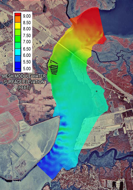
Water level distribution during design storm conditions. Click to enlarge.
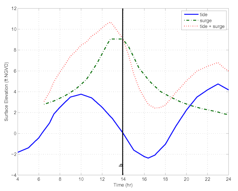
Tide and surge levels under design conditions. Click to enlarge.
, Beach Nourishment")


